

 简体中文
简体中文
 Russian
Heavy rain and snow in the same frame. Is the climate this year intense?
In the past two days, the weather intensity in southern my country, especially South China, has gradually escalated. For example, starting from April 26, a squall line swept through places such as the Pearl River Delta and violent storms in Guangzhou and Shenzhen. On April 27, multiple supercells swept through Guangdong and Guangxi. Extreme storms and huge hail occurred in the northern part of the Pearl River Delta. Around 3 p.m., a tornado appeared near Zhongluotan Town, Baiyun District, Guangzhou, and nearby netizens photographed a huge funnel. Electric sparks flew everywhere where the tornado went, and iron sheets were swung like pieces of paper. A furniture factory was overturned, causing a huge impact.
1. Extremely heavy rain and snowstorm in the same frame
In fact, from April 27 to April 28, 2024, my country's climate was extremely changeable. Not only was there fierce convection along the South China coast, but the intensity of the precipitation was also very extreme - a heavy snowstorm in the north on one side, and a heavy snowstorm in the south on the other. Extremely heavy rainstorms, clashes between warm and cold air masses, and extreme rainfall intensity have brought a lot of troubles to people's lives.
First, let’s take a look at the severe snowstorm in the north. From April 27 to April 28, rare snowfall occurred in central Inner Mongolia and northern Hebei, and accompanied by thunder and lightning, heavy snowstorms occurred in the Zhenglan Banner and Duolun areas in the southern Xilingol League, with the amount of snowfall (turning into water) exceeding 30 mm. , there is snow this morning, with 11 centimeters in Zhenglan Banner and 17 centimeters in Duolun. The snow accumulation in Toronto is the second highest in April observation history, second only to 19 centimeters in April 2008. The snowfall is still continuing. From April 28th to April 29th, the snow accumulation in Toronto may break the local April record.
What is the cause of this heavy snowstorm? This is due to the combined effect of a cold air and a cold vortex moving southward. Cold air refers to the air flow transported from high latitudes to low latitudes. Its temperature is low, its density is high, and its pressure is high. It can push warm air to high altitudes, creating unstable atmospheric conditions that are conducive to the occurrence of precipitation. Cold vortex refers to a low-pressure rotating airflow formed at high altitude. Its central temperature and pressure are low, which can attract the surrounding warm and moist airflow to form a strong upward movement, which is conducive to the development of clouds and produces heavy precipitation. When cold air and a cold vortex affect an area at the same time, a cold vortex thunderstorm is formed, which is precipitation accompanied by thunder and lightning. If temperatures get cold enough, precipitation can turn into snow or even blizzards.
So, why are the cold air and cold vortex so strong this time? This is related to the changes in the westerly belt. The westerly belt refers to an air current blowing from west to east in mid- and high latitudes. Its intensity and position change with seasonal and climate changes. Generally speaking, the westerly winds in winter are stronger than those in summer and are located further south. The strength and location of the westerly belt will affect the activities of cold air and cold vortex. If the westerly belt fluctuates violently and moves southward, the cold air and cold vortex will be stronger and easier to move southward. In late April this year, the fluctuation amplitude of the westerly belt was huge, which caused the cold air and cold vortex to move abnormally strong and southward, triggering a heavy snowstorm in the north.
2. Is the climate this year intense?

Next, let’s take a look at the heavy rainstorms in the south. Last night and this morning, our country encountered extremely heavy rains and extremely heavy snowfalls at the same time! Among them, there were heavy rains and heavy rains in the central and eastern parts of Guangdong. The 24-hour rainfall at Shanwei National Station was 262.6mm, reaching the level of heavy rainstorms. This was the second strongest daily precipitation in Shanwei in April. , the trend of less precipitation in eastern Guangdong since the second half of last year has been completely reversed; the precipitation belt has basically left Guangdong, but a new wave of strong convection may appear in the afternoon.
What is the cause of this heavy rain? This is due to the combined effect of a strong warm and humid air flow and subtropical high pressure. Warm and humid airflow refers to the airflow transported from low latitudes to high latitudes. It has high temperature, low density, and low pressure. It can press cold air at low altitudes to form stable atmospheric conditions, which is conducive to the accumulation of water vapor and increases precipitation. potential. The subtropical high refers to an air flow that sinks from high altitude to low altitude in the subtropical region. Its central temperature is high and the pressure is high, forming a strong sinking movement. There is a strong warm and moist air flow at the edge of the subtropical high. The recent strong The subtropical high pressure controls the vicinity of southern my country, pushing strong warm and moist airflow into southern my country, triggering intense strong convection and heavy rains.
So, why are the warm and humid airflow and subtropical high pressure so strong this time? This may be related to the El Niño phenomenon. El Niño refers to a climate phenomenon in which sea water temperatures rise abnormally in the equatorial Pacific. Its cycle lasts about 2 to 7 years and will have a major impact on the global climate. In April this year, the El Niño phenomenon continued even though it was weakening, which may have indirectly led to the unusually strong and persistent warm and moist air flow and subtropical high pressure, which triggered extremely heavy rains in the south.
3. Extreme cold and warm air masses
From the above analysis, it can be seen that the extremely heavy rain and snowstorm occurred at the same time, showing that the intensity of both cold and warm air masses in my country is very strong, and the precipitation intensity is relatively extreme. This is closely related to the changes in the westerly belt and the El Niño phenomenon. Changes in the westerly belt have led to the unusually strong and southward movement of cold air and cold vortices, as well as the unusually strong and persistent southern warm and moist airflow and subtropical high pressure. These changes cannot be ruled out as being due to the impact of global climate warming. Global climate warming will lead to energy imbalances in the atmosphere and oceans, causing instability and abnormalities in the climate system. It is also related to the El Niño background.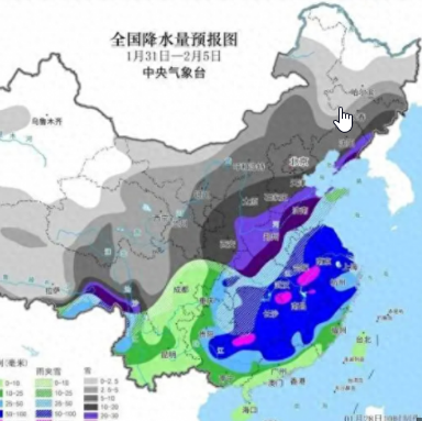
So, will this weather phenomenon continue? Expert analysis points out that this depends on the development trend of the westerly belt and El Niño phenomenon. If the westerly belt continues to be stronger and more southerly, the fluctuating temperature trend in the north may continue after May, which will have an adverse impact on agricultural production and so on. If the El Niño phenomenon continues, the risk of rainfall and flooding in the southern summer and autumn cannot be ignored.
For example, the Yangtze River Water Conservancy Commission held a flood control consultation in March and pointed out that during the 2024 flood season (April-October), the climate in the Yangtze River Basin will generally deviate. The precipitation in the basin will be more than normal, but the spatial and temporal distribution of precipitation will be uneven, and floods will be heavier than droughts. Among them, the upper reaches of the Yangtze River are basically normal, while the middle and lower reaches of the Yangtze River are more common. During the main flood season (June-August), precipitation in the Yangtze River Basin is above normal, with rainfall in the upper reaches of the Yangtze River being above normal, rainfall in the middle and lower reaches of the Yangtze River being above normal, and rainfall near the main stream in the middle reaches possibly reaching more than 20%. This forecast points out that we should focus on preventing possible major floods in the main stream of the middle and lower reaches of the Yangtze River and the northern part of the two lakes system. Therefore, everyone should pay close attention to the forecasts and early warnings of the meteorological department and take timely countermeasures to reduce losses and ensure safety.

A woman jumped from a shopping mall in Guangdong and hit a p
A woman jumped from a shopping mall in Guangdong and hit a p...(950 )人阅读时间:2024-04-28
A new picture of prosperity and development in the West
A new picture of prosperity and development in the WestOn th...(725 )人阅读时间:2024-04-28
Heavy rain and snow in the same frame. Is the climate this y
Heavy rain and snow in the same frame. Is the climate this y...(959 )人阅读时间:2024-04-28
Questions from the community respond to M7 rear-end fire, 3
Questions from the community respond to M7 rear-end fire, 3 ...(747 )人阅读时间:2024-04-28A new picture of prosperity and development in the West
A new picture of prosperity and development in the WestOn th...2024-04-28Heavy rain and snow in the same frame. Is the climate this y
Heavy rain and snow in the same frame. Is the climate this y...2024-04-28A woman jumped from a shopping mall in Guangdong and hit a p
A woman jumped from a shopping mall in Guangdong and hit a p...2024-04-28Questions from the community respond to M7 rear-end fire, 3
Questions from the community respond to M7 rear-end fire, 3 ...2024-04-28